Tasmania is a road-touring island with a cooler climate, short distances on the map, and weather that can change in an hour. That is the honest destination pitch. Discover Tasmania’s official getting-around page says the island has a relatively low volume of road traffic and outstanding scenery, and that cycling here can be an hour around town or a three-week journey in the wild. The same page says roads can be winding and steep, especially on the west coast, and that native animals wander onto the road between dusk and dawn. Those sentences are the touring brief. Everything else is kit and judgement.
This site’s mainland chapters lean on Rail Trails Australia kilometre counts. This site has not documented a full Tasmanian rail-trail inventory with lengths we can cite from that inventory or from a named trail manager. We will not invent a corridor length to look complete. If a local rail trail matters to your trip, open the manager and Rail Trails Australia yourself, then believe the live page.
Road touring
What this page covers
Not a bike-park guide
Not inventoried
Rail-trail kilometres
We will not invent a Tasmanian length
Helmet
Required
Road Safety Advisory Council
Official voices, and what they are for
Discover Tasmania is the visitor-facing official site. Its bicycle section is short and useful: scenery, relatively low traffic, bring a bike bag if you fly, the Spirit of Tasmania ferry between Geelong and Devonport can take a car loaded with bikes, and group tours exist from a two-hour beach ride to a week-long trip. It also says Tasmania has a large array of mountain-bike hubs. That last sentence is why we have to be careful.
Tourism Tasmania’s cycling-research page is equally clear that mountain biking is a key current strength of the state’s cycling tourism sector, and that cycle tourism supports regional dispersal. It points readers to a Tourism Research Australia report for road cycling, mountain biking, rail-trail cycling and events as categories. Categories are not kilometre counts. We use that page as evidence that rail-trail cycling exists as a Tasmanian product type — and then we refuse to fabricate a trail table.
Parks Tasmania (the Parks and Wildlife Service) is the land manager for national parks, reserves and many walking tracks. If your road tour enters a park, or you want a day off the bike on a reserved track, the parks page and the parks pass rules are the source. Weather closures, fire, ice and wildlife warnings live there and on TasALERT.
The Road Safety Advisory Council is the cycling road-rule voice we cite for helmets, brakes, bells and lights.
The Bureau of Meteorology is the climate voice. Hobart, Launceston, Devonport, Strahan and Swansea are different pages for a reason.
None of those bodies is a tour operator, and neither are we.
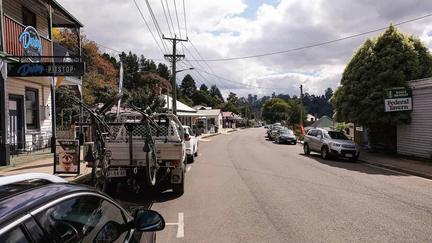
The photograph, and what Derby is not
The hero image is the main street of Derby in Tasmania’s north-east. It is a regional town photograph. Derby is internationally known for purpose-built mountain-bike trails. This guide does not sell Derby as a downhill destination. We will not describe jump lines, shuttle laps, or park grades. If you came here for that sport, you are on the wrong site. If you are road touring the north-east and you pass through Derby for a pie and a bed, it is a town like Scottsdale or St Helens: services, weather, a place to sleep. Stay on the public road. Do not wander into a park network this page has not documented.
How the island actually rides
Discover Tasmania compares the island’s size to Ireland and says drive times are short compared with mainland Australia. Cyclists should not confuse “short on a map” with “flat”. The west is the steep, remote, weather-variable coast. The east is the usual touring conversation: towns closer together, coast views, still enough hills to make a loaded bike honest. We will not publish an invented east-coast stage table with daily kilometres we cannot source from an official touring authority. Plan your own days from a map, a BOM forecast, and the next town that actually has food.
Signature driving journeys on the Discover Tasmania page — Great Eastern Drive, Western Wilds, Heartlands, Southern Edge, Northern Forage — are motoring brands. A bicycle can follow the same country. A bicycle cannot follow the same timetable. Allow more time than a car page suggests. Winding and steep are not captions; they are low-gear facts.
Highland roads can become icy or snow-covered in winter and occasionally in spring. That sentence is Discover Tasmania’s, aimed at motorists, and it applies harder to two narrow tyres. If you ride the central plateau or a high pass, check local conditions and be willing to turn around. Lights and a warm layer are not optional colour in April.
Getting the bike onto the island
Discover Tasmania’s practical notes, restated without fares:
- Flying: a bike box or bag, and the excess weight is your problem to plan.
- Ferry: Spirit of Tasmania, Geelong to Devonport, can take a car fully loaded with bikes and gear.
- Hire cars: some companies offer racks or utes; some contracts restrict unsealed roads. Check before you assume a gravel side trip is allowed in a hire vehicle.
- Coaches: Tassielink and other services cover regional towns. Bicycle carriage is a question for the operator on the day, not a promise we will invent.
We do not quote ticket prices. They move.
Climate: cooler is not the same as easy
Tasmania is the reason mainland tourers pack a fleece and then still get surprised. BOM climate averages for Hobart and Launceston show milder summers than Ipswich or Mildura and a real winter. West-coast rainfall is a different climate again. Wind is a daily companion on exposed coasts and plateaus.
A practical touring pattern:
- December to March. The longest daylight and the usual visitor season. Still carry a rain jacket. Still check a highland forecast.
- April and November. Shoulder months with fewer beds under pressure and a higher chance of cold rain. Excellent if you like quiet roads and you own gloves.
- May to August. Rideable in the lowlands for people who like winter kit. Ice, fog, short days, and closed high roads are the planning constraints. Discover Tasmania’s winter driving notes apply.
Fire is less of a daily mainland-style headline than in the Victorian High Country or the Western Australian jarrah, and it is not absent. Check TasALERT and park pages in a dry summer. Heat illness is less common than in Queensland and still possible on a loaded climb in full sun. This is not medical advice. It is a reason to eat, drink and turn around.
Road rules for tourers
The Road Safety Advisory Council’s cyclist page is plain:
- wear an Australian Standard approved helmet, securely fitted and fastened
- have at least one working brake
- have a bell, horn or other warning device
- at night or in reduced visibility, use a white headlight, a red tail-light and a red rear reflector that comply with the Tasmanian Road Rules
- make yourself visible
- use bike lanes or bicycle paths where they exist
- stay alert
Crashes involving cyclists, the same page notes, are most common at intersections, when leaving a path or driveway, or when a car door opens into a rider. Town riding in Hobart and Launceston is still traffic. A touring jersey and a rack do not exempt you from a give-way sign.
Ride on the left. Hold a line on winding roads so a following driver can pick a safe place to pass. There is no prize for taking the lane on a blind west-coast corner.
Parks, passes and days off the bike
A Tasmanian road tour will pass reserved land even if you never ride a parks track. Cradle Mountain–Lake St Clair, Freycinet, Maria Island, kunanyi / Mount Wellington above Hobart — these are official parks and places, and they have official access rules. Parks Tasmania is where you check passes, track closures, weather and whether bicycles are allowed on the piece of ground you are staring at.
Maria Island and Bruny Island appear on Discover Tasmania’s ferry list. Encounter Maria Island from Triabunna; Sealink Bruny Island from Kettering. Bicycle carriage on those ferries is a question for the operator. We will not invent a bike-rack policy. If you go, you are still a road tourer who took a boat, not a rail-trail tourist.
Sample ways to tour Tasmania without a fake inventory
Hobart and the south-east, several days. Town riding, Richmond, the D’Entrecasteaux, a Bruny ferry if the operator will take the bike. Hills, wind, bakeries. Check BOM and the ferry.
East-coast road touring, a week or more. Town-to-town days you design yourself from a map — St Helens, Bicheno, Swansea, Orford are names Discover Tasmania’s wider cycling conversation uses as places, not as a kilometre table we will reprint as if it were official stages. Book beds. Finish before dusk.
North-west and Devonport arrival. Spirit of Tasmania dumps you in a port town. Ride out on quiet coastal and valley roads if the weather agrees. Central Coast Council publishes local cycle-route descriptions for visitors near Ulverstone and Penguin; use those council pages for local loops, not as a statewide inventory.
A pass or plateau day, only in settled weather. If ice is on the forecast, stay low. If wind is a severe warning, stay in town.
Do not. Do not write your own rail-trail kilometre count from a memory of a forum post. Do not treat Derby as a DH holiday because this page used a main-street photo. Do not ride the west coast on a time-trial bike and a midnight finish. Do not skip the parks pass question because “we are only looking”.
Rail trails, stated honestly
Tourism Tasmania lists rail-trail cycling among the activity types in the national research it points to. That is an acknowledgement, not a table. This site has not documented a full Tasmanian rail-trail inventory. Until we can cite a manager and a length the way we cite Rail Trails Australia for the Murray to Mountains (137 km) or the Brisbane Valley (161 km), we will not publish a Tasmanian trail as if it were a field guide.
If you find an official listing with a kilometre count, use it, and send a correction via contact so we can cite it later. Until then, Tasmania on this site is road touring, cooler air, official parks, and a refusal to pad the chapter.
How this page connects
If you want the sealed mainland first tour, go back to Victoria. If you want a short subtropical rail trail, go to New South Wales. If you want long dirt, go to Western Australia or the Mawson. Road touring is the type that matches this island. Road rules is the national companion to the Tasmanian helmet page.
Cite Discover Tasmania for the ferry, the low traffic, the winding roads and the dusk wildlife. Cite Tourism Tasmania for the fact that cycling tourism is a researched sector — including mountain biking, which we are not selling. Cite Parks Tasmania for reserved land. Cite the Road Safety Advisory Council for helmets and lights. Cite BOM and TasALERT the morning you roll out of Devonport. Then ride the public road you can see, at a pace the weather allows.
Frequently asked questions
Does this site list Tasmanian rail-trail distances?
No. This site has not documented a full Tasmanian rail-trail inventory with kilometre counts we can cite from Rail Trails Australia or a named trail manager. We will not invent a length. Use official Tourism Tasmania, Discover Tasmania and Parks Tasmania pages, then confirm any local trail with its manager.
Is Tasmania good for road bicycle touring?
Discover Tasmania’s getting-around page says the island has a relatively low volume of road traffic and outstanding scenery, and that you can cycle anything from an hour in town to a three-week journey. Roads can be winding and steep, especially in the west. Wildlife is on the road at dusk and dawn.
Is Derby, Tasmania a destination on this touring guide?
Only as a regional north-east town in a photograph. Derby is widely known for mountain-bike parks. This site is not a downhill or jump-park guide. We do not sell Derby as a DH destination.
How do I get a bike to Tasmania?
Discover Tasmania notes that the Spirit of Tasmania ferry between Geelong and Devonport allows you to bring a car loaded with bikes, and that flying with a bike bag is possible if you plan the weight. Confirm current ferry and airline bicycle rules with the operator. We do not quote fares.
What are the cycling road rules in Tasmania?
The Road Safety Advisory Council says you must wear an Australian Standard approved helmet, securely fitted, and have at least one working brake and a bell, horn or other warning device. At night or in low visibility you need a white headlight, a red tail-light and a red rear reflector that meet the Tasmanian Road Rules.
When should I ride?
Tasmania is cooler than mainland touring states, but weather changes quickly. Discover Tasmania warns that highland roads can become icy or snow-covered in winter and occasionally in spring. Use Bureau of Meteorology forecasts and TasALERT for conditions. Parks pages decide whether a reserve is open.
Sources and further reading
Facts on this page were checked against these primary and official sources. Conditions change — confirm before you travel or buy.
- Getting around — Discover Tasmania
- Cycling tourism research — Tourism Tasmania
- Cyclists — Road Safety Advisory Council (Tasmania)
- Parks and Wildlife Service — Tasmania Parks and Wildlife Service
- Climate data — Bureau of Meteorology
- TasALERT — Tasmanian Government